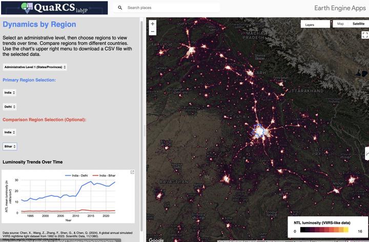
Regional dynamics of VIIRS-like nighttime lights 1992-2023
When the sun goes down and the lights turn on, there’s still a lot to explore.
Let’s study regional development from outer space!
Let’s study regional development from outer space!
🌐 A Global Annual Simulated VIIRS Nighttime Light Dataset (1992-2023)
- Authors: Xiuxiu Chen, Zeyu Wang, Feng Zhang, Guoqiang Shen, Qiuxiao Chen
- Published in: Scientific Data (2024)
- DOI: https://doi.org/10.1038/s41597-024-04228-6
🔬 Background & Summary
- Nighttime light (NTL) data is widely used to measure human activity, urbanization, and socioeconomic trends.
- Existing NTL datasets (DMSP-OLS & NPP-VIIRS) have limited temporal coverage and inconsistencies.
- The study presents a new dataset, SVNL (Simulated VIIRS NTL), using deep learning to provide a continuous, high-resolution (500m) dataset from 1992-2023.
- SVNL allows for long-term monitoring of human activity and urbanization trends.
📚 Data Collection
- DMSP-OLS Stable NTL (1992-2013): Oldest available nighttime light dataset.
- NPP-VIIRS Annual VNL V2 (2012-2023): Higher resolution and more accurate than DMSP.
- Landsat NDVI (1992-2013): Used to improve calibration and reduce saturation.
- Other datasets: Extended NTL datasets (ChenVNL, LiDNL), GDP data, and administrative boundaries.
🎯 Research Framework
- Step 1: Preprocess and calibrate DMSP-OLS NTL data for consistency.
- Step 2: Develop and train a U-Net super-resolution network (NTLSRU-Net) for cross-sensor calibration.
- Step 3: Apply the trained model to convert DMSP NTL into VIIRS-like data (1992-2011).
- Step 4: Merge simulated VIIRS data (1992-2011) with real VIIRS data (2012-2023) to create SVNL dataset.
🤖 U-Net Super-Resolution Model
- The model enhances spatial resolution and corrects inconsistencies between DMSP & VIIRS.
- Modifications:
- Removed pooling layers to preserve spatial details.
- Used transposed convolutions for up-sampling.
- Integrated Landsat NDVI data to correct for saturation.
- Model trained using DMSP & VIIRS data from 2012-2013 and then applied for historical reconstruction.
🌍 Evaluation & Validation
- Accuracy Assessment:
- Histogram and scatter plot comparisons between SVNL & real VIIRS data (2012-2013).
- High correlation observed at pixel, city, province, and national levels.
- Spatial Pattern Validation:
- SVNL data closely matches real VIIRS data, avoiding saturation issues in urban areas.
- Temporal Trend Validation:
- SVNL aligns well with economic indicators (GDP growth) and urban expansion patterns.
🔄 Key Findings
- SVNL dataset provides a high-resolution, long-term global record of nighttime lights.
- Outperforms previous datasets by maintaining spatial and temporal consistency.
- Enables more accurate studies on urbanization, socioeconomic trends, and environmental monitoring.
- Publicly accessible for researchers and policymakers.
💡 Conclusion
- The SVNL dataset fills a crucial gap in long-term nighttime light data.
- Facilitates detailed analysis of human activities from 1992-2023.
- Future work includes further refinements using additional remote sensing data.
- Dataset Access: Original data repository
- GEE dataset Access: Awesomme GEE community catalog
- Exploratory Tool: GEE web app by Carlos Mendez
See web app in full screen HERE
Carlos Mendez
Associate Professor of Development Economics
My research interests focus on the integration of development economics, spatial data science, and econometrics to understand and inform the process of sustainable development across regions.