Regional dynamics of DMSP-like nighttime lights 1992-2019
When the sun goes down and the lights turn on, there’s still a lot to explore.
Let’s study regional development from outer space!
Let’s study regional development from outer space!
Title Slide
- A Harmonized Global Nighttime Light Dataset (1992–2018)
- Authors: Xuecao Li, Yuyu Zhou, Min Zhao, & Xia Zhao
- Published in: Scientific Data (2020)
- DOI: https://doi.org/10.1038/s41597-020-0510-y
🌍 Introduction
- Nighttime light (NTL) data provide insights into human activity, urbanization, and economic development.
- Two primary sources: DMSP/OLS (1992–2013) & VIIRS (2012–2018).
- Challenge: Significant inconsistency between DMSP and VIIRS data.
- Objective: Develop a harmonized global NTL dataset for long-term analysis.
👩💻 Data Collection
- DMSP/OLS NTL Data (1992–2013):
- Downloaded from the Payne Institute for Public Policy.
- Digital number (DN) values range from 0 to 63.
- Spatial resolution: 30 arc-seconds.
- VIIRS/DNB Data (2012–2018):
- Higher spatial & radiometric resolution.
- Monthly composites were processed into annual data.
- Spatial resolution: 15 arc-seconds.
🔄 Methodology
- Three-step harmonization process:
- Annual Composition of VIIRS Data:
- Used cloud-free coverage data as a weighting factor.
- Removed noise from aurora, fires, and temporary sources using thresholding techniques.
- Applied a weighted averaging approach to generate annual composite images from monthly VIIRS data.
- Conversion of VIIRS to DMSP-like Data:
- Kernel Density (KD) Approach:
- Aggregated VIIRS radiance data (15 arc-seconds) to match DMSP resolution (30 arc-seconds).
- Used a Gaussian point-spread function to reduce differences in radiance distribution.
- Logarithmic Transformation:
- Applied logarithmic transformation to adjust radiance variations in urban, suburban, and rural areas.
- Reduced differences in brightness levels between high and low radiance pixels.
- Sigmoid Function Conversion:
- Developed a sigmoid function based on 2013 data to map transformed VIIRS data to DMSP-like DN values.
- Parameters of the function were optimized at a global scale and validated at continental and national levels.
- Kernel Density (KD) Approach:
- Integration of DMSP & VIIRS Data:
- Inter-calibrated DMSP data (1992–2013) using a stepwise calibration approach.
- Applied derived sigmoid function to convert VIIRS data (2014–2018) into DMSP-like DN values.
- Merged both datasets to create a consistent 27-year global NTL dataset.
- Annual Composition of VIIRS Data:
🌍 Technical Validation
- Histogram Comparison:
- Compared DN distributions of inter-calibrated DMSP and VIIRS-derived DMSP-like data.
- Verified similarity in data distributions for overlapping years (2012–2013).
- Identified a slight increase in high DN values (>60) due to DMSP saturation effects.
- Temporal Consistency (1992–2018):
- Assessed trends in total nighttime light (NTL) intensity and number of lit pixels.
- Conducted analysis using different DN thresholds (7, 20, 30) to minimize low-luminance noise.
- Observed a stable and continuous trend in high-luminance areas (DN > 20).
- Spatial Validation:
- Evaluated spatial accuracy using major metropolitan areas (e.g., Beijing, New York).
- Compared observed DMSP, raw VIIRS radiance, and DMSP-like VIIRS data.
- Verified agreement in urban spatial patterns, indicating robustness of the integration approach.
- Independent Socioeconomic Correlations:
- Compared trends with external socioeconomic indicators (e.g., GDP, electricity consumption).
- Strong correlations between harmonized NTL dataset and economic development patterns.
- Ensures reliability of dataset for studies on urbanization and economic growth.
🏰 Applications of the Dataset
- Urban expansion analysis (e.g., Beijing-Tianjin region).
- Socioeconomic studies (e.g., GDP estimation, electricity consumption).
- Environmental monitoring (e.g., light pollution, carbon emissions).
- Disaster impact assessments (e.g., conflict zones, power outages).
📊 Key Findings & Conclusion
- The harmonized NTL dataset enables long-term analysis (1992–2018).
- Overcomes DMSP-VIIRS inconsistencies using a systematic integration approach.
- Provides a valuable resource for urbanization, economics, and environmental studies.
- Dataset Access: Original data repository
- GEE dataset Access: Awesomme GEE community catalog
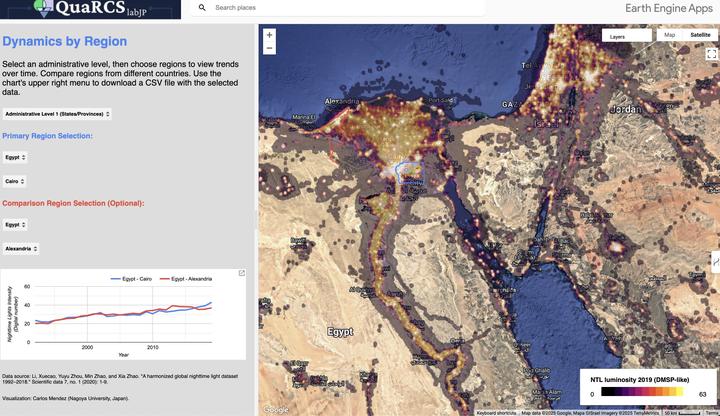
- Exploratory Tool: GEE web app by Carlos Mendez
See web app in full screen HERE
Carlos Mendez
Associate Professor of Development Economics
My research interests focus on the integration of development economics, spatial data science, and econometrics to understand and inform the process of sustainable development across regions.